|
|
|
|
The "Live-Anywhere" Boat - Cruise 2015, Part XIV, Delft to Terneuzen
Updated March, 2016
|
Canal Bridge, Delft
|
Rotterdam Harbor - The Erasmus Bridge (BNP Photo)
|
Rotterdam Skyline (BNP Photo)
|
The Willemsbrug (Willem's Bridge), Rotterdam (BNP Photo)
|
Alongside in the Wijnhaven, Dordrecht
|
|
On the first sunny day in quite a while, we headed down the Delftsche Schie. We passed several loading docks in the outskirts of Rotterdam, and in about an hour and a half were waiting for the Parkhaven Lock.
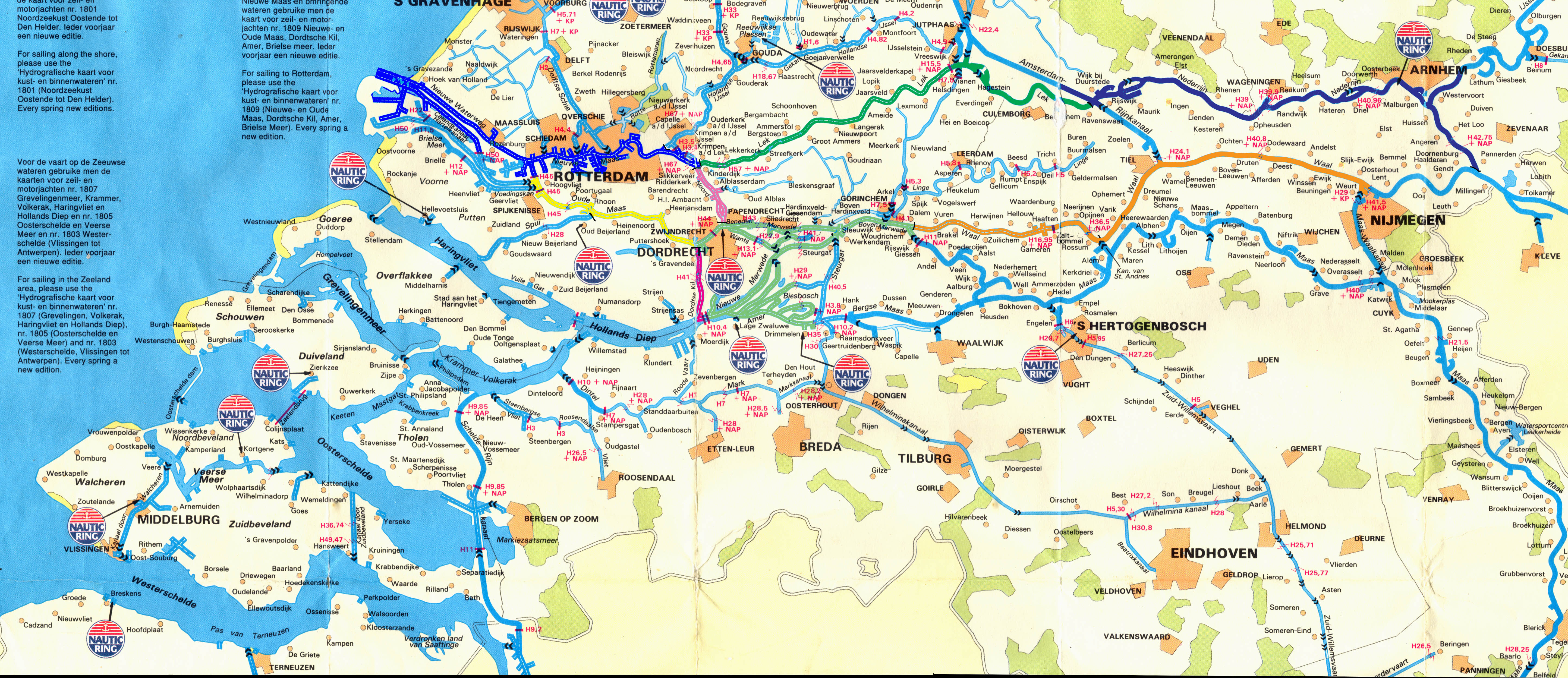
If our travels from here on are to make any sense, I must first say a little bit about the geography of the southern third of the Netherlands. This area is essentially the delta formed by two great rivers, the Rhine and the Meuse, with the Scheldt thrown in on the southern end for good measure. There is a map that may help with this description.
|
Classic Neighbors
|
Astern of Us in the Wijnhaven
|
|
The Rhine (Rijn in Dutch), after running from Switzerland all the way through Germany as a perfectly normal river, runs into the Netherlands from the east and immediately starts branching out. Just east of Nijmegen a small branch runs northwest as the Nederrijn ("Lower Rhine"), and a tiny spur of that runs through Leiden simply as the Rhine, our old friend. Pretty soon, however, the Lower Rhine becomes the Lek and flows on toward Rotterdam and the coast. Before reaching Rotterdam. however, it becomes, somewhat inexplicably, the Nieuwe Maas (the "New Meuse"), in which guise it is the central stream of Rotterdam Harbor.
The real Meuse runs north through France and Belgium and along the Dutch side of the German border until it turns west just south of Nijmegen and flirts with the remainder of the Rhine at Zaltbommel. It continues southwest until losing its identity in the swamps of the Biesbosch, becoming the Amer, and flowing out into the vast estuary Hollands Diep.
The main stream of the Rhine becomes the Waal at Nijmegen, but later becomes various species of Merwede ("Upper," "Lower," "New") and splits, part of it going on to Dordrecht, and part southwest to Hollands Diep. At Dordrecht, most of the Merwede goes on, now as the Oude Maas (the "Old Meuse"), to join Rotterdam Harbor west of the city, while a canal branches off as simply Noord to join the Lek where it becomes the Nieuwe Maas.
|
Sign that is a Throwback to a Commercial Past
|
The Rhine Delta --- Click on Map for Larger Version
|
|
So Dordrecht is a major junction, and just west of the center, another stream called the Dordtse Kil runs south to join Hollands Diep, which, in turn, splits into the Haringvliet and the Volkerak. Just south of these are the Oosterschelde and Westerschelde, the Eastern and Western Scheldt estuaries. The more important of these is the Western branch, which carries some 15,000 seagoing ships a year up to Antwerp, Europe's second-busiest port.
|
More Classic Vessels
|
A Quiet Back Canal in Dordrecht
|
|
Rotterdam, however, is Europe's busiest port, with an average of 100 ships per day. Most of these berth below the city itself, but they often unload into inland ships, that of course run up the rivers, and even some of the sea-going ships can be seen farther up. So, as we headed out of the lock and poked our nose out of the Parkhaven, we immediately received a call from Traffic
Control, wanting to know our destination. We proceeded up the "New Meuse," dutifully changing our primary radio to the correct control frequency every couple of miles, until we turned right into Noord, the canal that leads south to Dordrecht.
|
Back Corner of the Dordrecht City Hall
|
Fish Market - Dordrecht
|
|
Our berth was to be in the Wijnhaven, which required us to cross the Merwede just as it becomes the Oude Maas, and wait, in the current and sitting across the traffic pattern, for the tiny Boombrug to open. Here, the Traffic Control helped us, warning oncoming ships of our position and situation.
Soon enough, we were through the bridge (which is only 7.7 meters wide) and secured in the harbor, which is mostly populated by larger classic boats.
|
Wall Tile - Dordrecht
|
|
Because of its strategic location, Dordrecht is a very old city, dating back to the 13th century. We had been there before, by land, and I well remember sitting at a cafe on the point where the three waterways meet and hearing an old gentleman explain: "That way goes to Rotterdam, that way goes to Germany, and that way to Belgium." This time we had come from Rotterdam and would be headed in a few days toward Belgium.
|
Coat of Arms on the Main Gate - Dordrecht
|
|
Like many Dutch cities, Dordrecht has a compact and well-preserved old town, and it is always a pleasure to walk down these streets lined with 16th- and 17th-century houses. Dordrecht is also a ship-captains' town, lacy with harbors, and a great number of inland ships proudly carry "Dordrecht" as hailing port on their sterns. If there are now more yachts in the harbors than we remember, that is perhaps to be expected.
|
Back Street and View of the Church of Our Lady (Grote Kerk) - Dordrecht
|
|
The commercial ships are now generally too large to fit into these old harbor cuts and have moved to the outskirts, along with the shipyards, but Dordrecht is still the sixth largest seaport in Holland.
We lay over two days in Dordrecht, then, on Monday, September 21st, headed out through the Boombrug. This bridge is essentially a blind alley, with very poor sightlines in either direction. We had advised Dordrecht Control by radio, and they held us in the bridge approach, still half in the open drawbridge, until a ship passed in front of our nose, and then allowed us to cross and turn left for the Dordtse Kil.
|
Side Gate Opening to the Dordtse Kil
|
The Groothoofdspoort (the Great Main Gate) - Dordrecht
|
|
We then had the almost immediate left turn into the Kil, but as we thought we would have to wait for an oncoming ship, Control advised us that she was also bound for the Kil and would follow us, so we had no trouble after all.
This part of Dordrecht is very industrial, with big-ship harbors, full of cranes, but soon the Kil became more rural and we were again running through meadows full of cows.
|
The Door to the Imperial Mint, Dordrecht
|
|
Distances in Holland are not really large. An hour after leaving the Boombrug, we were turning right to join the procession of ships heading for sea in Hollands Diep. We followed the buoyed channel, keeping well to the right and letting the big ships overtake us. Hollands Diep is a big estuary, over a mile wide in places, and it was a pleasure to be out of the confines of a canal for a while.
Barbara romped thorugh the chop, and soon it was time to turn into the harbor at Willemstad. We had called ahead, but it was not clear, either from the charts or the descriptions in the Water Almanac, just where we should go, so we followed the buoys cautiously into the harbor mouth, wondering if we should turn to the right or the left into one of the Jachthavens. As we wondered, however, a figure appeared on the deck of the Harbor Office and waved us on, into the innermost harbor, where we found a space just our size on the quay in front of the town, exactly the kind of spot we like.
|
Headed Out Through the Main Gate (BNP Photo)
|
|
Willemstad was built in the late 16th and early 17th centuries, after Holland was free of the Spanish occupation, specifically as a fortress. The seven bastions commemorate the seven provinces that united to repel the Spanish. The old walls were prettty much replaced by earthen ramparts in the early artillery age, but the town is well preserved and very picturesque.
We walked around the town, and had a good dinner at "El Miguel" the night of our arrival. The next day was a rainy Sunday, and we did some sightseeing betweeen the showers and filled our water tanks. We were interested in the Koepelkerk, built in 1607 as the first Protestant church built in the Netherlands.
The German Army took over Willemstad in the spring of 1940 and mined the harbor entrance. Later that year, an inland ship carrying Belgian POWs toward Germany ran onto a mine and sank, killing everyone aboard. The recovered bodies are buried in a special cemetery next to the harbor.
|
The Steps Leading Down to Our Berth, Dordrecht
|
Alongside in the Old Harbor, Willemstad
|
|
We left Willemstad on a rainy morning, with a northwest wind of 15 to 20 knots. We turned immediately into the Volkerak Lock, which we shared with a big tanker and a passenger tour boat. The lock did not operate as fast as the huge locks on the Mittelland Canal, but after a short while we were released into a gray and rainy Volkerak, where the wind freshened to 35 knots with maybe 45-knot gusts.
We had about a seven mile run, through the gray, flat, fenlands of North Brabant, before we reached the left turn into the Schelde-Rijnverbindung, the Rhine-Scheldt Connecting Canal. This trip pointed up a weakness of our chart- plotting program, "PC- Navigo." It is very good at finding routes through the canals, and quite informative, but does not allow waypoints, and we would have been glad of a few in this feature-poor landscape.
|
The Orangemolen ("Orange Mill") - Willemstad
|
Former City Hall - Willemstad
|
|
A few miles down the canal, we turned right and retraced our steps behind the dike that protects the water side of Tholen, our next stop. The entrance was a little confusing, since we had to dodge a dredge and her attendant workboats in a narrow space (shades of the Elbe-Havel Canal!), but with a little chat on the radio and a little patience, we were able to go on up to the very head of the harbor, where we berthed at the Duivendijk Shipyard. This small yard is still in the Duivendijk family and does very good work in a pattern we found familiar; the husband runs the shop, and the wife does the books and runs the office.
|
Looking Back at the Town from the Ramparts - Willemstad
|
Willemstad - Our Berth Marked by a Star
|
|
We stayed longer than we had originally intended in Tholen. I had been increasingly bothered by an old Rugby injury, and with an Atlantic crossing impending it seemed like a good idea to get some medical attention. Actually, I should probably have done that in Leiden, where we had some built-in infrastructure, but of course I figured it would work itself out.
|
Our Neighbors in the Harbor - Willemstad
|
Coffee on the Harbor Front - Willemstad (BNP Photo)
|
|
In the event, I found a very helpful doctor, who gave me some pain medication and referred me to an excellent physical therapist. After two weeks of stretching and massage, the spasms in my shoulder abated enough that I decided the situation was managable and we could go on.
Meanwhile, I worked on the boat, doing preventive maintenance on the engine in preparation for the crossing, and trying to coax better performance from the Hurricane heater. This had worked flawlessly all winter, but now, when we would have liked some heat to cheer us up on gray rainy days, refused to burn properly. The wood stove worked fine, of course, and Barbara had good luck in finding wood from someone who was remodeling an old building, and from a worker in the yard who was tearing some old oak out of a boat to do some kind of refit, but the heater would really have helped. When it works, it is great, but it seems to be somehow delicate, as though the margins are small, and although I cleaned everything in sight, and replaced some key parts, a proper flame just could not be made to last very long. If it does not do better after being spoken to at home by someone who really knows these systems, it will be time to find a different solution to the heat problem.
|
Allee in the Cemetery - Willemstad (BNP Photo)
|
|
We found Tholen a very pleasant place to spend a little time. All the stores we needed were close by, and, as a regional center with plenty of tourism, it has many bars and restaurants. We took advantage, re-supplying the boat and watching football games.
Barbara, in particular, met many people, among them a lawyer who was turning a 17th-century house, that had been used by a bank, back into a house again. A major concern was what to do with all the safe-deposit boxes. She also met a very pleasant Belgian family, Jan and Françoise, living aboard their small tjalk. As we met them, their two sons had come to help sail the boat back to Belgium for the winter, so they were a little crowded but very cheerful.
Barbara had one interesting surprise; when she went to what she thought would be a simple concert, she found that it was really a gathering of church choirs from all over the region, assembled for a recording session. Barbara was welcome to attend, but was expected to sing, which was no problem of course. The outcome was to be a new Christmas CD, to be sold for the benefit of Syrian refugees.
From Tholen, it is possible to go to Antwerp by a protected canal, passing by Bergen op Zoom and through the Kreekrak Locks, but we did not want to go to Antwerp. Instead, we turned right at the end of the Rhine-Scheldt Canal into the equally large Bergse Diep Locks, that matched the water level of the tide and released us into the Eastern Scheldt.
|
The Koepelkerk - Willemstad (BNP Photo)
|
The Former Moat - Willemstad (BNP Photo)
|
Overtaken by the Light Tanker Somtrans XXVI (BNP Photo)
|
Duivendijk Shipyard - Tholen
|
|
The Eastern Scheldt is a hugely broad estuary, full of sandbanks and scoured by nine-meter tides. We were very happy that the channel is well-bouyed, but in any case we did not have far to go.It is only about seven miles from the Bergse Diep Locks to Wemeldinge, where we turned south into the somewhat unimaginatively named "Canal Through South Beveland." This led us south through about four miles of alternating marsh and industry to Hansweert and the Western Scheldt.
Here, we joined the parade of sea-going ships headed out to sea from Antwerp, and stayed well out of the way of the inbound procession. Every part of this estuary has a name; we ran east of the flats of the Rug van Baarland into the sweeping westerly curve of the Gat van Ossenisse.
The flooding tide held us up a little, but the distance was again not great, and in something over an hour we made up the entrance to Terneuzen Harbor. Here the tide was an issue, sweeping past the harbor entrance and leaving whirlpools in its wake. We had to time our turn to avoid the oncoming traffic and still miss the mudbanks on either side of the moles protecting the harbor.
|
Tholen
|
|
We got in all right, though I did not like to think of what would happen if the engine failed, but we were still not certain where to go. We did see a float, however, at the end of a long ramp (we were still near the bottom of a 27-foot tide), and we decided that was the place for us. Here we rode the huge tides in comfort.
|
Church of Our Lady - Tholen
|
The Head of Tholen Harbor
|
|
We spent the afternoon walking in the town, and about everyone we met told us that Terneuzen was the home town of the Flying Dutchman, the captain who vowed to get around the Cape of Good Hope if he had to sail forever, which, of course, he then had to do.
This attribution appears to go back to Frederick Marryat, the early 19th-century naval officer, writer of sea stories, and friend of Charles Dickens.
|
Boats Awaiting Attention - Tholen
|
|
It is perhaps a stretch to credit Marryat as the originator of the sea story (a good case could be made, for example, that Homer is the first writer of sea stories, just as he originated so many other genres), but he was certainly a great influence on such important writers of the sea as C.S. Forester, Joseph Conrad, and Patrick O'Brian.
Marryat did not invent the core of the story, but he did localize the captain as Willem van der Decken, living in a house on the Havenstraat ("Harbor Streeet") in Terneuzen with his wife and children, and in Terneuzen the legend is treated as Gospel.
Marryat's book is called The Phantom Ship, but there have been many other versions of the story, most notably, perhaps, the opera Der fliegende Holländer ("The Flying Dutchman"), by the young Richard Wagner. In the opera, but not Marryat's novel, the unnamed Dutchman is saved at the last moment by a selfless act of love.
It is perhaps also appropriate that the planes of KLM, the Royal Dutch Airline, all carry the motto: "The Flying Dutchman."
|
Church of Our Lady - Tholen
|
Classic Yachts in Tholen Harbor
|
|
Across the wharf from our berth were the impressive tugs and smaller workboats and line-handling tugs of "Multraship," a marine towing and services company based in Terneuzen. The Dutch are famous for deep-sea towing, and even if Multraship is not a huge company, its equipment is clearly at the state of the art.
|
Doorways - Tholen
|
Windmill De Verwachting - Tholen
|
|
We did not linger long in Terneuzen. Our stay in Tholen, longer than we had expected, put us a little behind schedule, and we needed to push on if our plan for a family Christmas in the British Virgin Islands was to come to fruition. We expected some weather-related delays in the more offshore parts of our trip, so we wanted to leave enough time in hand.
|
Back Corner - Tholen
|
|
In the event, we left the next morning, waiting for a moment when there was not a ship running by just outside the harbor, and swinging around into the locks at the head of the Canal from Terneuzen to Ghent.
|
Classic Tjalk on the Way to Our Berth (BNP Photo)
|
The Entrance to the Bergse Diepsluis
|
|
|
Ship Traffic on the Western Scheldt
|
Fishing Boat and Yachts in Terneuzen Harbor
|
|
|
Barbara in Front of the Arsenal - Terneuzen
|
|
|
The Old Post and Telegraph Office - Terneuzen
|
|
|
Entrance to the Massive Terneuzen Locks
|
Ship Passing Just Outside Terneuzen Harbor (BNP Photo)
|